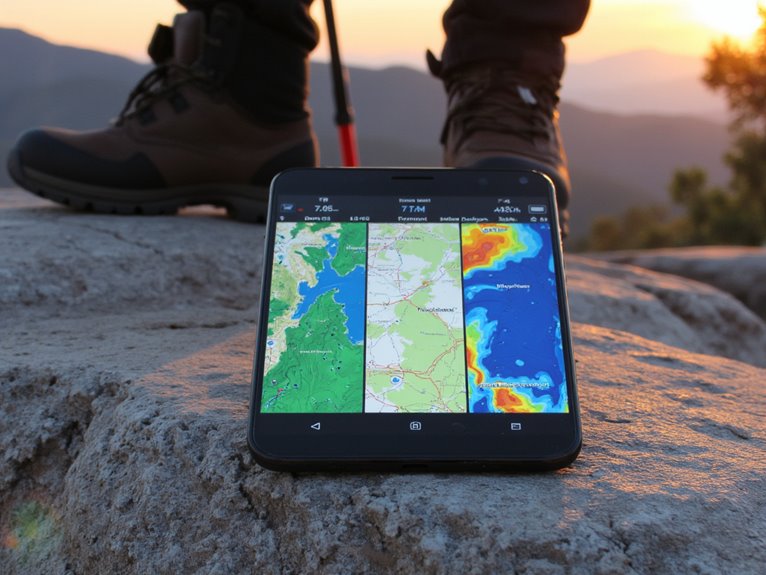
Using AllTrails, Gaia GPS, and CalTopo for Trip Planning
You’ll need different apps for different adventures: AllTrails excels at day hiking with 450,000+ trails and user reviews, while Gaia GPS dominates backcountry navigation using authoritative USGS topographic data. CalTopo provides the most advanced terrain analysis with slope visualization and avalanche risk assessment tools. AllTrails costs $35.99-79.99 annually, Gaia GPS runs $39.99/year, and CalTopo offers $40-80/year subscriptions. Each platform’s specialized features and pricing structures reveal ideal use cases for your specific outdoor activities.
We are supported by our audience. When you purchase through links on our site, we may earn an affiliate commission, at no extra cost for you. Learn more. Last update on 6th January 2026 / Images from Amazon Product Advertising API.
Notable Insights
- AllTrails excels for day hiking with user reviews and turn-by-turn navigation, ideal for popular trail discovery.
- Gaia GPS provides superior wilderness navigation with USGS topographic data and offline mapping for backcountry exploration.
- CalTopo offers advanced route planning with customizable maps, slope analysis, and avalanche risk assessment for technical users.
- All three platforms support offline maps and weather integration, essential for safe trip planning in remote areas.
- Choose based on experience level: AllTrails for beginners, Gaia GPS for experienced hikers, CalTopo for technical planning.
Map Quality and Coverage Comparison
When selecting trip planning software, map quality and coverage serve as the foundation for safe and successful outdoor adventures.
AllTrails excels in global trail diversity with user-friendly features like contour lines, hill shading, and building footprints on their flagship map. However, map detail diminishes in remote areas. The platform provides satellite imagery alongside trail data for comprehensive visual reference.
AllTrails offers excellent trail coverage and intuitive mapping features globally, though detailed cartography weakens in isolated wilderness locations.
Gaia GPS delivers authoritative topographic data from USGS, USFS, and international sources, offering superior map detail for backcountry exploration. Its layer overlay capability creates custom map combinations ideal for technical navigation. The app incorporates crowd-sourced maps that allow for more detailed features not found in other platforms.
CalTopo specializes in customizable US-focused maps with government datasets, slope angle shading, and hazard overlays.
You’ll find AllTrails best for popular trails, Gaia GPS best-suited for wilderness navigation, and CalTopo superior for advanced backcountry planning with specialized data layers.
Performance and User Interface Analysis
Three distinct performance profiles emerge when comparing these trip planning platforms, each optimized for different user workflows and technical demands.
CalTopo delivers consistently superior performance benchmarks, handling massive datasets like the 8,000-mile Great Western Loop without slowdowns. Desktop browsers process CalTopo’s route editing efficiently, while Gaia GPS occasionally struggles on high-resolution displays.
User feedback reveals clear interface preferences. AllTrails’ container model appeals to casual hikers seeking straightforward navigation.
Gaia GPS provides excellent mobile trail-snapping but suffers responsiveness issues when editing routes with multiple layers. CalTopo’s power-user interface overwhelms beginners but excels at complex overlay management.
Auto-syncing works seamlessly in Gaia GPS across devices. For outdoor enthusiasts carrying essential gear, selecting appropriate sleeping pads becomes crucial for comfort during multi-day expeditions planned through these platforms.
CalTopo’s printing flexibility surpasses competitors, while AllTrails prioritizes smooth recording workflows for recreational users. CalTopo supports GPX file imports for enhanced customization capabilities. Gaia GPS offers access to comprehensive map sources with over 251 different mapping layers available through its premium membership.
Route Planning and Customization Capabilities
Route planning sophistication varies dramatically across these three platforms, with each application targeting distinct user needs through specialized customization tools.
| Feature | AllTrails | Gaia GPS | CalTopo |
|---|---|---|---|
| Trail Database | 450,000+ trails | Limited trails | Minimal trails |
| Map Layers | 3 types | Multiple layers | Extensive layers |
| Offline Access | Pro version only | Full support | Available |
| Route Import/Export | Basic GPX | Full GPX support | Multiple formats |
AllTrails excels in trail discovery through its massive database and user-generated content. You’ll find thorough user experiences including photos and reviews that enhance route tracking decisions. Gaia GPS offers superior map customization with multiple overlay options and seamless GPX integration. CalTopo provides the most precise editing tools using USGS topographic data, making it ideal for technical route modifications and terrain analysis. While AllTrails provides comprehensive turn-by-turn navigation for improved route guidance, the other platforms focus more heavily on planning and mapping capabilities. AllTrails also offers satellite imagery overlays that enhance visual terrain assessment during route planning.
Safety Features and Terrain Analysis Tools
When you’re planning backcountry trips, understanding avalanche risk and weather conditions can mean the difference between a successful adventure and a dangerous situation.
CalTopo’s slope analysis tools let you visualize terrain angles above 30 degrees where avalanche risk increases notably, while its integrated weather layers provide snow depth and temperature data essential for evaluating snowpack stability.
AllTrails and Gaia GPS complement this with real-time weather forecasts that include precipitation patterns, wind speeds, and temperature fluctuations that directly impact trail safety and avalanche conditions. AllTrails Plus provides wrong turn alerts that notify you if you stray from the designated path, which is particularly crucial when visibility is compromised by weather conditions. AllTrails Plus also includes air quality index data to help you assess environmental conditions that could affect your breathing and overall safety during outdoor activities.
Avalanche Risk Assessment
While recreational backcountry travel continues growing in popularity, avalanche terrain assessment remains one of the most critical safety considerations that can mean the difference between a successful adventure and a tragic outcome.
Modern mapping platforms integrate sophisticated avalanche identification techniques to help you recognize dangerous terrain features before you encounter them.
CalTopo and Gaia GPS incorporate risk assessment algorithms that analyze slope angles, identifying critical zones above 30 degrees where avalanche release becomes possible. These platforms use color-coded shading to highlight slopes between 35-45 degrees-the highest-risk terrain.
Advanced runout zone prediction models apply alpha angles of approximately 22 degrees to estimate debris travel distances. These calculations consider natural terrain features like rock outcroppings and trees that can affect actual runout distances in the field.
You’ll find ATES classification overlays that differentiate terrain complexity, while terrain trap identification helps you avoid natural hazards like gullies and rock outcrops. Newer specialized platforms like Aspect Avy offer live tracking functionality that combines real-time positioning with LiDAR mapping for enhanced route navigation in avalanche-prone areas.
Weather Data Integration
Accurate weather forecasting becomes your primary defense against exposure-related incidents that claim more backcountry travelers than avalanches or wildlife encounters combined.
AllTrails refreshes weather data hourly, integrating fifteen environmental factors with user feedback integration to deliver trail-specific conditions. You’ll access mosquito activity levels, air quality readings, and precise sunrise times alongside standard meteorological data.
Gaia GPS layers National Weather Service forecasts directly onto topographic maps. The platform caches weather overlays offline, ensuring continuous access in no-signal zones.
CalTopo combines NOAA models with snowpack forecasts and wind direction indicators for thorough environmental analysis.
Weather source accuracy varies greatly between platforms.
AllTrails emphasizes localized hiking conditions, while Gaia GPS prioritizes backcountry navigation safety. CalTopo excels at terrain-specific weather modeling for technical route planning.
For emergency situations, consider carrying a paracord bracelet with integrated survival tools that can provide essential gear when weather conditions deteriorate unexpectedly.
Pricing Models and Subscription Options
Navigation apps operate on distinct pricing models that reflect their core design philosophies and target audiences.
AllTrails offers three tiers: free Base access, Plus at $35.99 annually, and Peak at $79.99 yearly. Plus adds offline maps and wrong-turn alerts. Peak introduces AI-powered route building and plant identification features.
Gaia GPS provides basic free access with Premium subscriptions around $39.99 annually. You’ll get offline topographic maps and advanced weather data.
CalTopo uses a freemium approach with Standard ($40/year) and Pro ($80/year) options focusing on map customization tools.
When conducting subscription comparisons, consider your specific needs.
AllTrails excels in community features, while Gaia GPS emphasizes backcountry navigation. CalTopo targets serious planners requiring custom mapping.
Membership benefits vary considerably across platforms, making feature alignment essential for selection.
Specialized Use Cases for Different Activities
Each navigation app excels in specific outdoor activities through specialized features and interface design tailored to distinct user needs.
AllTrails dominates day hiking with 400,000 curated trails and proprietary difficulty algorithms. You’ll find essential hiking essentials like turn-by-turn GPS navigation, real-time elevation profiles, and weather updates.
For backpacking gear planning, both AllTrails and Gaia GPS offer offline maps vital for multi-day trips. The Lifeline feature shares your location with emergency contacts during extended wilderness travel.
Mountain bikers benefit from activity-specific trail categorization and technical difficulty ratings.
Trail runners access surface type data and fitness-oriented metrics.
Gaia GPS provides sophisticated wilderness navigation through multiple mapping layers including topographic and satellite overlays.
Custom route creation and waypoint plotting enhance emergency preparedness capabilities across all platforms. When planning multi-day backpacking trips, water filtration systems become critical components that require strategic consideration alongside your digital navigation tools.
Choosing the Right App for Your Adventure Needs
Which navigation app best suits your outdoor adventures depends on your experience level, activity type, and technical requirements.
AllTrails excels for beginners seeking crowd-sourced trail reviews and straightforward navigation. Its freemium model provides adequate functionality for casual day hikers.
Gaia GPS serves experienced users requiring detailed topographic data and international map coverage. The $39.99 annual subscription grants access to National Geographic Trails Illustrated maps and advanced offline capabilities.
CalTopo targets technical users needing precise route planning with slope-angle shading and avalanche data. User feedback trends consistently highlight Gaia GPS’s superior map detail versus AllTrails’s community features.
App compatibility issues occasionally affect offline downloads across all platforms.
Choose AllTrails for simplicity, Gaia GPS for thorough backcountry navigation, or CalTopo for technical planning requirements. When selecting your shelter for multi-day trips, consider lightweight tents that pack efficiently while providing reliable weather protection for your planned route.
Frequently Asked Questions
Can These Apps Work Together or Sync Data Between Platforms?
These apps don’t offer true inter app compatibility or automatic data synchronization methods.
You’ll need to manually export GPX files from one platform and import them into another. This process transfers basic route data, waypoints, and tracks, but you’ll lose advanced features like CalTopo’s terrain analysis, AllTrails’ user reviews, or Gaia’s custom map layers.
Each platform maintains proprietary formats that prevent seamless integration.
These hiking apps don’t considerably drain your phone’s battery faster than standard navigation apps regarding basic battery consumption.
However, their continuous GPS tracking features reduce navigation efficiency compared to occasional route-checking in Google Maps or Waze. You’ll experience higher drain when using background tracking or complex map layers.
Cellular searching in weak signal areas affects all GPS apps equally. Use airplane mode and offline maps to optimize battery performance.
What Happens if I Lose Cell Service While Using These Apps?
Your offline capabilities remain fully functional if you’ve downloaded maps beforehand.
These apps use your phone’s GPS receiver, which works independently of cellular networks. You’ll maintain complete navigation access, location tracking, and route recording.
However, your user experience becomes limited-you can’t search new trails, get real-time updates, or access fresh content.
Pre-downloading essential map areas guarantees uninterrupted wilderness navigation.
You can share planned routes through multiple methods across these platforms.
AllTrails enables direct route sharing via app links or URLs, with recipients accessing routes without paid memberships.
Gaia GPS supports route sharing through GPX/KML file exports and cloud-based links.
CalTopo offers URL sharing with customizable privacy settings and collaborative permissions.
All three platforms facilitate effective trip collaboration through different sharing mechanisms tailored to various user preferences.
Do These Apps Work Internationally or Only in the United States?
You’ll find excellent international trail coverage across all three platforms.
AllTrails provides detailed information on over 400,000 trails worldwide, while Gaia GPS supports global topographic maps from international sources like OpenStreetMap.
CalTopo offers topographical maps from multiple countries with global satellite imagery.
You won’t encounter significant app compatibility issues internationally-each platform supports offline downloads and worldwide GPS tracking for remote areas.
On a final note
You’ll find each app excels in specific areas. AllTrails delivers superior trail discovery with 300,000+ verified routes. Gaia GPS provides professional-grade offline mapping with 40+ layer options. CalTopo offers unmatched terrain analysis through USGS integration and custom overlay capabilities. Your choice depends on primary use: casual hiking favors AllTrails, backcountry adventures require Gaia GPS, and technical route planning demands CalTopo’s advanced tools.