What Month Does It Start Snowing in Washington?
In Washington State, the onset of snowfall varies greatly depending on elevation and location. The Olympic Mountains typically see snow as early as October, with significant accumulation by November. In contrast, the Puget Sound region, including Seattle, may not experience significant snowfall until December or later. The Cascade Range transforms into a winter wonderland, offering endless opportunities for adventure and exploration. As you venture deeper into Washington's winter landscape, you'll uncover a world of snowpack formation, intense precipitation events, and unique regional snowfall patterns, each with its own story to tell.
Snowfall in the Cascade Range
Amidst the rugged grandeur of the Cascade Range, an average of 600 inches of snowfall blankets the towering peaks and valleys annually, transforming this Pacific Northwest mountain chain into a winter wonderland. The heavy snowfall is due to the range's proximity to the Pacific Ocean, which brings in moist air that collides with the cold air from the north, resulting in heavy snowfall. This unique combination creates an ideal environment for winter sports enthusiasts, who flock to the region's numerous ski resorts, such as Whistler Blackcomb and Stevens Pass. With its abundant snowfall, the Cascade Range is a haven for skiers, snowboarders, and snowshoers, offering endless opportunities for adventure and exploration in the snow-covered mountains.
Mountain Snow Vs. Lowland Snow
While the Cascade Range's towering peaks are awash in abundant snowfall, the surrounding lowlands experience a vastly different winter landscape, with snowfall amounts dwindling substantially as elevation decreases. The rugged mountains create an orographic effect, forcing moisture-laden air to rise, cool, and condense, resulting in heavy snowfall. In contrast, the lowlands, including cities like Seattle and Tacoma, receive markedly less snow due to their lower elevation and proximity to the moderating influence of the Puget Sound. This stark contrast highlights the unique characteristics of Washington's diverse geography, where snowfall can vary greatly over short distances. Understanding these regional differences is essential for predicting and preparing for winter weather in the Evergreen State, where forecasters must plunge into the complexities of local topography to accurately forecast snowfall totals.
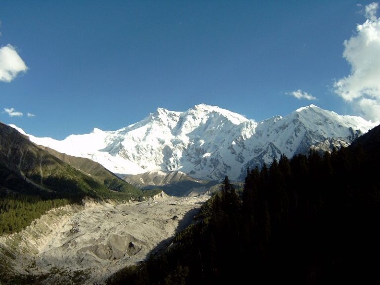
Early Snow in the Olympics
Beyond the rugged Cascade Range, the Olympic Mountains, situated on the Olympic Peninsula, are renowned for receiving some of the earliest snowfall in Washington State. This majestic mountain range typically sees snow as early as October, with significant accumulation by November. The Olympic Mountains' proximity to the Pacific Ocean and their high elevation create a unique microclimate, resulting in an abundance of precipitation. The snowpack in the Olympics can be substantial, with some areas receiving over 600 inches of snow annually. This makes the region a haven for winter sports enthusiasts, including skiers, snowboarders, and snowshoers. The Olympic Mountains offer a winter wonderland experience like no other in Washington State.
When Snow Hits the Coast
Coastal towns in western Washington, typically accustomed to mild winter weather, are occasionally surprised by rare snowfall events that transform their scenic landscapes into winter wonderlands. These unexpected snowfalls often occur when cold air from the north collides with moist air from the Pacific Ocean, resulting in a unique convergence of weather patterns. The coastal mountains, such as the Olympic Peninsula, can receive significant snowfall, with some areas receiving up to 10 inches of snow in a single event. While snowfall is rare in these areas, it can have a profound impact on daily life, causing road closures and disrupting daily activities. However, for those who live in these coastal towns, the rare snowfall events are a welcome treat, offering a chance to experience the beauty of winter in an otherwise mild climate.
Spokane's Winter Weather Patterns
Located in eastern Washington, Spokane's winter weather patterns are shaped by its inland location, where cold Arctic air masses from Canada collide with moist air from the Pacific Ocean, resulting in a distinct seasonal climate. This convergence of air masses leads to significant snowfall, with an average annual snowfall of around 45 inches. The snow season in Spokane typically begins in late November and lasts through February, with the heaviest snowfall occurring in December and January. The city's proximity to the Rocky Mountains also contributes to its cold winters, with temperatures often dropping below freezing. Overall, Spokane's winter weather patterns make it an ideal destination for winter sports enthusiasts and those who enjoy the festive atmosphere that comes with snow.
Snow in the Puget Sound Region
In stark contrast to Spokane's inland climate, the Puget Sound region, which includes Seattle and its surrounding cities, experiences a milder winter climate, with snowfall being a rare but welcome occurrence. The region's proximity to the Pacific Ocean and the Olympic Mountains creates a rain-shadow effect, resulting in limited snowfall. On average, Seattle sees only 6.8 inches of snow per year, with most of it falling between December and February. When snow does fall, it's often a light dusting, but occasionally, a more significant snowfall can occur, bringing the city to a standstill. Despite the rarity of snow, the Puget Sound region's residents enthusiastically anticipate the possibility of a winter wonderland, and even a light snowfall can bring excitement and joy to the area.
Eastern Washington's Snow Season
Beyond the Cascade Range, Eastern Washington's snow season unfurls in a dramatic contrast to the mild winters of the Puget Sound region. Here, the landscape transforms into a winter wonderland, with snow-covered mountains, frozen lakes, and rolling hills blanketed in white. The snow season in Eastern Washington typically begins in November and lasts through March, with the heaviest snowfall occurring in December and January. Popular destinations like Spokane, Leavenworth, and the Methow Valley offer a range of winter activities, including skiing, snowshoeing, and ice fishing. As the snowflakes fall, Eastern Washington comes alive with festive atmosphere, making it an ideal winter getaway for outdoor enthusiasts and those seeking a snowy escape.
Seattle's First Snow of Winter
While Eastern Washington's snow season is a winter wonderland, Seattle's first snow of winter brings a unique charm to the Emerald City, transforming its vibrant streets and iconic landmarks into a serene winter scene. The snowflakes gently fall, casting a magical spell on the city, as residents and visitors alike revel in the rare winter wonder. Seattle's snowfall is often light, with an average annual snowfall of just 6.8 inches, making each snowfall a special event. The city's snow-covered rooftops, frozen lakes, and snow-dusted evergreens create a picturesque backdrop for winter activities like ice skating, snowshoeing, and hot chocolate-sipping. As the snowflakes fall, Seattle comes alive with a festive atmosphere, making its first snow of winter a truly unforgettable experience.
Winter Weather in the San Juans
The San Juan Islands, an archipelago of over 450 islands and rocks, transforms into a tranquil winter haven as the Pacific Northwest's stormy weather patterns bring precipitation and cold temperatures to the region. The islands' unique geography creates a microclimate, shielding them from the worst of the storms, but still allowing for a dusting of snow and frost. Winter is a peaceful time in the San Juans, with fewer tourists and a serene atmosphere. Outdoor enthusiasts can enjoy kayaking, birdwatching, and hiking in the crisp winter air. The islands' rural landscapes and picturesque villages take on a serene beauty, making the San Juans an ideal winter getaway for those seeking a tranquil escape from the city.
Snowfall in the North Cascades
As we shift our focus to the North Cascades, we enter a domain of rugged peaks and abundant snowfall. Here, the combination of Pacific moisture and cold air from the north creates a perfect storm for mountain snowpack formation, with some areas receiving over 1,000 inches of snow per year. Winter storm patterns play a vital role in shaping the region's snowfall, with powerful low-pressure systems bringing heavy snow and strong winds to the range.
Mountain Snowpack Formation
Beyond the misty veil of the North Cascades, winter storms trigger a fury of snowfall, blanketing the rugged peaks with a thick layer of white. As the snow accumulates, it transforms into a crucial component of the region's ecosystem: the mountain snowpack. This natural reservoir stores water for the dry summer months, feeding rivers and streams that support aquatic life. The snowpack's formation is a complex process, influenced by various factors.
- Elevation: Snowpack forms at higher elevations, where temperatures are colder and precipitation is more abundant.
- Temperature: Cold temperatures preserve the snowpack, while warm temperatures can cause it to melt.
- Wind: Strong winds can redistribute snow, affecting its distribution and depth.
- Soil: The underlying soil's moisture and temperature impact the snowpack's formation and melting.
Winter Storm Patterns
Winter storm patterns in the North Cascades are characterized by intense precipitation events that trigger heavy snowfall, often exceeding 1,000 inches annually in the highest elevations. These storms form when moist air from the Pacific Ocean collides with the rugged mountain terrain, resulting in rapid snow accumulation. The North Cascades' unique topography creates an orographic effect, where air is forced to rise, cool, and condense, leading to massive snowfall. This phenomenon creates some of the most extreme snowfall totals in the country, making the North Cascades a powder hound's paradise. The resulting snowpack is essential for water supply, agriculture, and recreation, making winter storm patterns a fundamental aspect of Washington's climate.